

Recommended




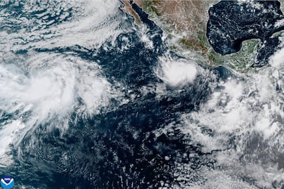
Southwestern Mexico braced on Wednesday for coastal flooding and landslides after Polo, a powerful Pacific cyclone, became a major hurricane. Meteorologists also warned that Hawaii could face another bout of severe weather later in the week.
The U.S. National Hurricane Center (NHC) in Miami described Polo as an “extremely dangerous” storm expected to brush the Mexican state of Guerrero, submerging coastal areas with 4 to 6 inches (10 to 15 centimeters) of rain through Thursday.
At its peak, Polo was a Category 5 hurricane with maximum sustained winds of 180 mph (290 km/h). By Wednesday morning, it was a Category 4, but still packing maximum sustained winds of 150 mph (241 km/h).


“Fluctuations in intensity are expected, but Polo is forecast to remain a very powerful major hurricane for the next few days,” the NHC said.
Waves, flooding, and landslides pose a danger
Mexican President Claudia Sheinbaum noted that experts indicated it was unlikely for Polo to make landfall. Even so, tropical storm conditions were expected along the Pacific coast in the states of Guerrero, Michoacán, and Colima through Thursday.
Hurricane-force winds extend outward up to 40 miles (65 km) from the storm's center, while areas up to 105 miles (169 km) from the eye will be buffeted by tropical-storm-force winds, meteorologists said. Polo was about 165 miles (266 km) south of Zihuatanejo and 320 miles (515 km) southeast of Manzanillo on Wednesday, the center reported.


Concepción López Villegas was busy reinforcing her seaside restaurant in Lázaro Cárdenas, Michoacán, ahead of the predicted heavy rain. Heavy surf was already pounding the beaches, and López Villegas feared the storm would destroy the small business she had worked for decades to build.
“We are worried and trying to protect our businesses," she said. "And, of course, we are sad because it is our heritage, our legacy, which could be destroyed at any moment.”
NHC data shows that Polo’s winds reached speeds comparable to a few hurricanes that reached the region in recent decades, most notably Patricia, whose winds reached 215 mph (346 km/h) in 2015.
On Tuesday, Polo became the third Category 5 hurricane of the Pacific season, following Genevieve and Lowell.

El Niño fueled the rapid intensification
The rapid intensification of Hurricane Polo has stunned both scientists and authorities, and the NHC wrote in a report that it was “truly remarkable” how quickly Polo gained strength in just 24 hours.
Philip Klotzbach, a research scientist at Colorado State University's Department of Atmospheric Science, attributed the intensification to the weather phenomenon known as El Niño, which has fueled devastating droughts in Mexico and Central America and flooding in other parts of the region.
In the Pacific, he said, it has resulted in warmer waters and wind patterns that serve as fuel for hurricanes.
“All the ingredients that hurricanes need to get really strong really fast are there,” Klotzbach stated.

Odalys gains strength and becomes a hurricane
Meanwhile, Hurricane Odalys was churning in another part of the Pacific Ocean on Wednesday, with maximum sustained winds of 75 mph (120 km/h).
Odalys was moving about 1,265 miles (2,036 km) west-southwest of the southern tip of Mexico's Baja California peninsula, and was not at risk of making landfall, according to the hurricane center.
An advisory indicated that Odalys could increase in intensity over the next few days, but would likely weaken toward the end of the week.
Hawaii could face another hurricane
A tropical depression about 525 miles (845 km) south-southeast of the Hawaiian capital, Honolulu, could become a tropical storm by the end of the day and a hurricane by Thursday.
The hurricane center recommended the archipelago keep a close eye on the system's progress, which could drop 15 to 20 inches (38 to 51 centimeters) of rain on the Big Island. Meteorologists predicted “dangerous flooding and catastrophic landslides.”
The center of the cyclone is expected to approach the islands by Friday or Saturday.


[Publicidad]