

Recommended


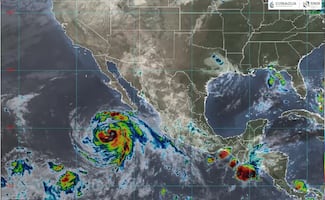


An unusual trio of hurricanes is crossing the Pacific Ocean this Thursday, whose waters have been warmed by a historically intense El Niño event.
Tropical Storm Marie strengthened and reached hurricane status late Wednesday off the coast of Baja California. It joins hurricanes Karina and Lowell, both Category 4, which are moving westward in the Pacific.
Having three active hurricanes at the same time is "definitely rare to observe," Julia Cole, a climatologist at the University of Michigan, told AFP.
"The warming caused by El Niño creates the conditions for these storms, which are driven in large part by warm waters," Cole explained.
Hurricane Lowell was located about 710 kilometers south of Hilo, Hawaii, the U.S. National Hurricane Center (NHC) reported.
"Swells generated by Lowell are spreading northward and will affect parts of the Hawaiian Islands in the coming days," the NHC stated, which could cause dangerous conditions near the coasts.
In 2015, when there was another particularly strong El Niño, a succession of four cyclones occurred.
This year's phenomenon has a 69% chance of becoming the most intense ever recorded, according to the U.S. National Oceanic and Atmospheric Administration.
El Niño occurs every two to seven years when the trade winds—currents that go from east to west and normally hold warm waters in the western Pacific—weaken temporarily. This causes those waters to rise to the surface and shift eastward.
When temperatures remain above normal for several months, more storms are generated in the region, which affects the planet's entire atmosphere.
As a result, the climate becomes warmer and drier in some places, and wetter in others.
Scientists agree that climate change amplifies its effects. However, there is no consensus as to whether it strengthens El Niño itself, although evidence to that effect has emerged.

[Publicidad]